


Hocking Hills Region: The Hiking Guide
Post Summary: The best hiking trails in the Hocking Hills Region, including tips and info.
People from all over come to hike in The Hocking Hills region since it is the most popular area in the state of Ohio. With over 10,000 acres of trails, waterfalls, caves, gorges, and more, wouldn’t you want to hike this gem?
These trails in Hocking Hills provide stunning waterfalls, cliffs, gorges, foliage, and more that showcase just how beautiful Ohio can be. The trails range from fairly easy to difficult and some trails get muddier than others after a rainfall. A lot of the trails are narrow so you may have to wait for people to pass and can also be rocky or steep in many spots so watch your step.
>> Related: Hiking As A Solo Female: 5 Tips <<
Cantwell Cliffs
An important thing to note is there is no cell service in and around the park; so you’ll either want to download an offline map or print directions. Many of the trails can be dangerous since they’re so close to cliffs to be extra careful when hiking. Also for the trails, Hocking Hills is especially adamant that you remain on the designated trails to avoid disrupting wildlife and ecosystems, not to mention it can be VERY dangerous to go off many of these trails.
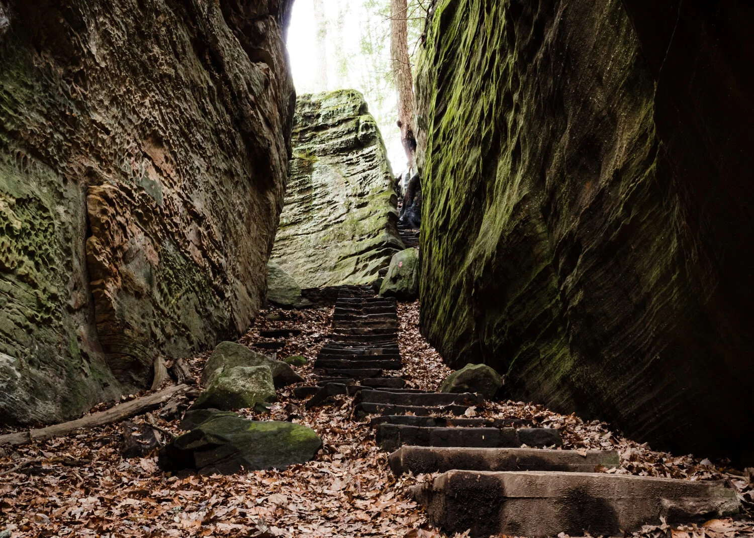
Ash Cave Trail (combines Gorge + Rim)
The Gorge trail begins in the parking lot and ends at the cave as a loop; this trail is also handicap accessible since the trail is paved. But you can continue on to the Rim trail for another half mile that will lead back to the parking lot. The gorge trail to the cave is handicap accessible.
Length: 1-mile loop
Difficulty: easy/moderate, heavily trafficked
Cedar Falls Trail
There’s two ways to begin this trail since there’s two parking lots on both ends of the trail. Both trailheads will lead you downstairs into the gorge for views of the falls. I’d recommend parking at the main lot, as it gives you more of a walk with views of the river and gorge, whereas the smaller lot will just lead you directly to the falls.
Length: 0.5 mile, out + back
Difficulty: moderate, heavily trafficked
Upper Falls to Lower Falls
Beginning in the Old Man’s Cave parking lot, you’ll go to the trail that is furthest from the Visitor Center. From here, you’ll walk across the bridge and then down the stairs to Upper Falls. There is the Gorge trail if you don’t head down the steps, but it doesn’t take you into the gorge, it’s just a rim trail that also leads to Cedar Falls or Rose Lake. From taking the steps, you’ll walk in the gorge and begin on the Grandma Gatewood trail, eventually coming to Old Man’s Cave. Technically you can get to Lower Falls by going through the cave, but I’d recommend continuing on the trail to Lower Falls. From there, you can either go back the way you came or go through Old Man’s Cave back to the Visitor Center.
Length: 2 miles, loop
Difficulty: moderate, heavily trafficked
Upper Falls to Whispering Cave
While Whispering Cave does have its own parking lot, I’d recommend hiking from the Old Man’s Cave area. You’ll follow the same Grandma Gatewood trail as Upper to Lower Falls, but you’ll continue on the trail till you see signs for the Hemlock Bridge Trail and Whispering Cave at a fork. You could also get to Cedar Falls by going the other way at that fork.
Length: 5 miles, loop
Difficulty: moderate, moderately trafficked
>> Related: Hiking the Old Man’s Cave Area <<
Rock House Trail
There’s two parking lots, both will lead you onto the trail that will go to Rock House. The trail itself isn’t too hard, lots of stairs and you’re close to the cliff a lot, so watch your footing. The Rock House can get pretty busy depending on the time of day. The floor of it can also be pretty wet and dark at times.
Length: 1 mile, loop
Difficulty: moderate, heavily trafficked
Conkle’s Hollow Trail (combines Gorge + Rim)
Starting in the parking lot, you’ll have two options, the Rim and the Gorge trail. I’d recommend the Rim trail first, where you’ll walk along the top of the cliffs, be careful though as you can get very close to the edge. When done, you’ll end up back on the path that begins the Gorge trail, which will take you below the cliffs, there’s even a few mini waterfalls throughout it. Up until a certain point, the gorge trail is handicap accessible.
Length: 3 miles, loop/out + back
Difficulty: moderate/difficult, moderately/heavily trafficked
Cantwell Cliffs Trail (combines Gorge + Rim)
Cantwell Cliffs consist of towering cliffs and a rock shelter, narrow passageways, and some mini waterfalls. Use extra caution here. The rim trail is a bit of a scramble, but worth it in the end because of the views. Part of the trail may be a repeat due to combining the two trails, but it’s totally worth it especially with how short they are.
Length: 2 miles, loop
Difficulty: difficult, moderately trafficked
>> Related: Hiking In Ohio: Some Of The Best Trails In The State <<
Hocking Hills Trail (combines Ash Cave, Old Man’s Cave + Cedar Falls)
You can start at Ash Cave or the Old Man’s Cave area, but this trail will lead you through to the main spots in the park. I’d start at Upper Falls and take the Grandma Gatewood trail and take the fork for Cedar Falls and continue from there to Ash Cave before heading back.
Length: 6 miles, out & back
Difficulty: difficult, moderately trafficked
* The Grandma Gatewood trail is part of the Buckeye Trail and runs from Upper Falls to Ash Cave.


